Business Details
30 Years
experience
Your Trusted Land Surveyors in Pakenham
Established in 1996, our business was founded by Rob Nobelius, a licensed surveyor with over two decades of public sector experience. Starting with just two employees, we have grown to become Victoria's largest single-office cadastral survey firm, with 20+ staff including 12 family members. Our team combines generational expertise with cutting-edge technology to deliver precise surveying solutions for projects ranging from small urban subdivisions to large-scale developments exceeding 1,000 lots. We serve clients across Metro Melbourne, Geelong, Gippsland, and the Bass Coast, including first-time property developers, experienced landowners, and commercial clients.Our commitment to continuous education ensures our team maintains the highest industry standards while delivering tailored solutions for boundary disputes, land mapping, and bushfire management. With offices in Pakenham and Warragul, we pride ourselves on combining technical excellence with personalized service to unlock value for every client's property project.
Services
Subdivision Development
Boundary Dispute Resolution
Land Mapping
Town Planning
Bushfire Management
Details
- Year established: 1996
Highlights and features
- Family-owned business operating since 1996 with generational surveying expertise
- Largest single-office cadastral survey firm in Victoria with 20+ experienced staff
- Specialize in projects from 2-6 lot subdivisions to 1,000+ lot developments
- Utilize advanced technologies for accurate boundary mapping and land management
- Proven track record with both first-time property developers and major commercial clients
What people say
Quick, efficient service
Excellent time frames
Highly recommend
Reasonably priced
Part of our development team
Services
Subdivision Development
We specialize in transforming single land parcels into multiple lots through precise cadastral surveying. Our services cover small urban redevelopments of 2-6 lots to large-scale projects exceeding 1,000 lots. From initial boundary mapping to final documentation, we ensure compliance with all regulatory requirements while maintaining project timelines.
Boundary Dispute Resolution
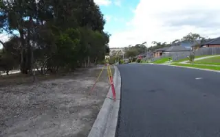
Our licensed surveyors resolve land boundary conflicts by re-establishing title dimensions and providing legally recognized documentation. We physically mark boundaries, analyze historical records, and deliver clear evidence to prevent neighbor disputes over property encroachments. This service benefits homeowners, rural landowners, and developers.
Land Mapping
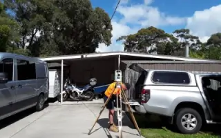
We create detailed topographical maps showing existing features and elevations for construction or subdivision projects. Our mapping services include title boundary verification, site analysis, and digital modeling to support accurate development planning and infrastructure design.
Town Planning
Our planning experts assist with navigating regulatory requirements for land use changes and development approvals. We prepare comprehensive plans for residential estates, commercial lots, and mixed-use developments while ensuring compliance with local council regulations and environmental considerations.
Bushfire Management
We provide specialized bushfire risk assessments and management strategies for land development projects. Our services include creating defensible spaces, designing firebreaks, and preparing bushfire management plans that balance development needs with safety requirements in high-risk areas.
People
Ben Nobelius
Managing Director, Licensed Surveyor
Ben has led survey operations since 2011, specializing in large residential estates. He brings generational expertise from family surveying traditions and focuses on community engagement while managing business growth.
Tim Walker
Director, Licensed Surveyor
Tim joined in 2011 after working with the Surveyor General of Victoria. He focuses on business development and professional growth within the surveying industry while balancing family commitments.
Rob Nobelius
Founder/Director, Licensed Surveyor
With surveying experience since 1975 and a business administration background, Rob founded the company in 1996. He has grown the team from 2 to 20+ employees while maintaining industry leadership.
Tarryn McCann
Subdivision Manager
Tarryn manages subdivision applications and office operations with 12 years of experience. She coordinates between surveyors, engineers, and legal representatives to ensure timely project delivery.
Julie Bowyer
Senior Town Planner / Bushfire Planner
Julie combines a journalism background with planning expertise, holding a Master of Planning & Environment. She specializes in bushfire risk assessment and sustainable development practices.
Questions
What surveying services do you offer?
We provide subdivision development, boundary dispute resolution, land mapping, town planning, and bushfire management services for residential and commercial clients.
How do you handle boundary disputes?
Our licensed surveyors re-establish title boundaries, provide legal documentation, and physically mark disputed areas using precise cadastral surveying methods.
Which areas do you service?
We operate across Metro Melbourne, Geelong, Gippsland, and the Bass Coast regions of Victoria.
What experience do you have with large developments?
Our team manages projects from 2-6 lot subdivisions to large estates exceeding 4,000 lots with dedicated survey managers for complex sites.