Empowering Communication, Enhancing Lives
Welcome to Jurovich Surveying, the market-leading survey firm dedicated to providing professional surveying services to the construction and land development industries. Our work spans across various sectors, from large scale mining and industrial projects to small scale commercial and residential projects. This extensive experience has given us in-depth knowledge across a wide range of areas, enabling us to deliver the best surveying services in the industry.
Our team of professional, licensed engineering and land surveyors is based in Perth, Sydney, and Adelaide. We are equipped with the latest techniques and state-of-the-art equipment to manage projects of all sizes efficiently and accurately. Our extensive knowledge ensures that we complete jobs quickly, accurately, and most importantly, correctly the first time.
Our Services: Comprehensive Surveying Solutions
At Jurovich Surveying, we offer a comprehensive range of surveying services, including:
- Resources & Infrastructure Surveying: We provide surveying services for various resource and infrastructure projects, including mining, construction, and engineering projects. Our services include volume calculations, setting out, and as-built surveys.
- Commercial Surveying: We offer commercial surveying services for various property development projects, including shops, offices, and industrial sites. Our services include boundary identification, area computations, and lease surveys.
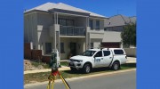
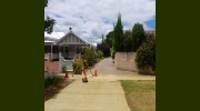
- Residential Surveying: We provide residential surveying services for various property development projects, including single dwellings, subdivisions, and units. Our services include boundary definition, planning surveys, and building format plans.
- Reality Capture: We utilise reality capture technology to create 3D models of sites, structures, and objects. Our services include 3D scanning, photogrammetry, and point cloud processing.
- Aerial Surveying: We use unmanned aerial vehicles (UAVs) to capture aerial imagery and data for various applications. Our services include aerial mapping, orthophotos, and 3D models.
- Laser Scanning: We use laser scanning technology to capture precise and detailed measurements of sites, structures, and objects. Our services include 3D modelling, point cloud processing, and scan-to-CAD.
- Utility Locating & Mapping: We locate and map underground utilities, such as pipes and cables, to prevent damage during excavation. Our services include electromagnetic detection, ground-penetrating radar, and utility mapping.
- Ground Penetrating Radar: We use ground-penetrating radar (GPR) to detect and map subsurface features, such as pipelines, utilities, and archaeological artefacts.
- Hydrographic Surveys: We conduct hydrographic surveys to measure and map the underwater topography of various water bodies. Our services include bathymetric surveys, sedimentation studies, and water volume calculations.
Our Projects: Delivering Excellence in Surveying
At Jurovich Surveying, we have a proven track record of delivering high-quality surveying services for various projects. Some of our valued clients include Monadelphous, Primero, and Westbourne Constructions. Our featured projects include the Barker Inlet Power Station, the Esprit Mascot Apartments, and the Primero Duration project.
Meet Our Team: Experienced and Qualified Surveyors
Our team of over 50 professional staff includes well-trained, competent, and professional surveyors. All of our surveyors are suitably qualified and are eligible to be members of the Surveying and Spatial Sciences Institute. Our Licensed Surveyors possess a current practicing certificate from the Land Surveyors Licensing Board. Our senior team includes Brad Jurovich, Director, and Gordon Jones, Cadastral Survey Manager/Licensed Surveyor.
Discuss a Project: Let's Work Together
If you like what you see, let's work together. Contact us to discuss a project and discover how we can provide you with the best surveying services in the industry. We look forward to hearing from you.

Be the first to review Jurovich Surveying.
Write a Review